If you’re going to visit Bryce Canyon National Park, it’s only natural to ask about it’s size. After all, you want to know just how much there is to see so you can plan your vacation accordingly. So, today we’re discussing how big is Bryce Canyon National Park.
A simple internet search will yield the information that Bryce Canyon National Park is approximately 55.98 sq miles. That decimal point might vary a bit as I’ve seen 55.992 sq mi. In metric, for all our overseas friends, Bryce comprises about 145.02 km2. It’s 10mi wide at its widest point and just over 20mi long. It stretches between Garfield and Kane Counties. Compared to the rest of the 62 national parks, Bryce Canyon ranks 51st in overall land area.
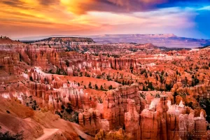
 Now that sounds like quite a bit of space to check out. However, you need to know that Bryce Canyon is situated on the eastern side of the Paunsaugunt Plateau. It’s also quite famous for its hoodoos: weather-worn sandstone rock formations resembling stalagmites without the cave and opposing stalactites. These hoodoos take up much of the park area. Plus, there is a cliff which you don’t want to randomly wander off the edge of. This natural barrier restricts much of the potentially usable area. Most of the usable park area exists on the plateau.
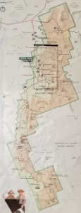
You’ll find that Bryce provides a road from one end of the park to the other, running north-south. This road is 18 miles long. Yes there are mile markers. Also, you’ll notice from the map, Bryce is a long and rather skinny strip of land on the edge of a plateau.
In summary, Bryce Canyon is one of the smaller United States national parks by land area. The hoodoos, for which the park is famous for, eat up much of the usable land. You can access much of the park from the rim of the canyon via the one and only road.


